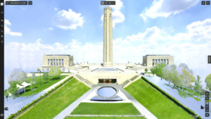
This featured dataset is the Qutub Shahi Tombs located in Hyderabad, India, home to Hexagon’s largest global Research & Development facility.
These vast monuments are the final resting place of various kings of the Qutub Shahi dynasty, who ruled the region of Hyderabad, eastern India, from the early 1500s to the late 1600s. The local government has been vying for it to become a fully recognised UNESCO World Heritage Site since 2014, and with an extensive restoration project has been ongoing since 2013.
To help preserve the site, a team of engineers recently created a digital twin of the grandest monument on the site – the tomb of Mohammad Quli Qutb Shah. Built in 1602, this houses the remains of the fifth sultan of the dynasty and the founder of Hyderabad after the fall of the ancient city of Golconda.
To help preserve the site, Hexagon brought together a whole host of cutting-edge autonomous digital reality devices, such as the RTC360, BLK360, BLK2GO, and BLK2FLY which capture reality with speed, ease, accuracy and incredible detail. The data is then processed in proprietary software including Leica Cyclone REGISTER 360+, Leica Cyclone 3DR and Reality Cloud Studio, powered by HxDR, a cloud-based all-in-one solution powered by our HxDR platform.
The end result is a data-rich digital twin that can be used for exploring, maintaining and restoring the heritage monument.
Some other highlights from this project:
- Over 10.7 billion points were captured to create this data-rich digital twin.
- About 600 GB of raw data was collected during the reality capture, which was then processed into about 320 GB of finished data
- More than 100 scan stations were set up to capture terrestrial scans using RTC360 and BLK2GO, covering an area of about 10,000 m2.
- A combination of BLK2GO and BLK360 were used to scan the crypt to cover an area of about 3500 m2.
- BLK2FLY, a cutting-edge autonomous flying scanner, used in mission mode captured the data of the facades and the upper parts of the dome – in just about 8 minutes.
- The highly accurate GS18 I RTK GNSS solution was used for geo-referencing the data to local coordinates systems.
- The HxDR platform allowed engineers from 3 global locations to collaborate on the 3D models simultaneously.
- Reality Cloud Studio, powered by HXDR, helped create rich interactive visualizations and VR output with its one-click operations and user-friendly features.
-
Scans:
Over 100 -
Dataset Size:
36 GB -
File Type:
LAS
Scanners:
-
Leica RTC360
-
Leica BLK360
-
Leica BLK2GO
-
Leica BLK2FLY
