Discover what’s new in HxDR Reality Cloud Studio. Get more value from your spatial data and increase ROI at every stage of your project.
We’ve introduced powerful new capabilities, including AI‑powered Classification, Scan vs BIM deviation analysis, improved integration with the suite of CloudWorx plugins (plus release of a new, free CloudWorx Viewer for Revit), an enhanced navigation experience with better motion and faster performance, and advanced GeoTag functionality to categorize shared information. These features are designed to support complex reality capture workflows while helping teams stay aligned, work more efficiently, and make informed decisions faster.
Keep reading to learn how our classification tool helps users filter and organize point cloud data when streaming within Leica CloudWorx plugins to support efficient model creation during Scan to BIM efforts, while the new Scan vs BIM deviation analysis verifies accurate comparisons between design intent and as-built conditions, helping teams stay on time and on budget, directly from the browser.
If you’re looking to reduce rework, improve accuracy, and deliver more value to your clients and stakeholders, these updates in Reality Cloud Studio are built for you.
Simplify your Scan to BIM Workflow with Supercharged Data
Optimize your Scan to BIM process by streaming classified point clouds into your favorite CAD applications for optimal efficiency, even with distributed teams.
Enhancements include:
- Shorten Project Timelines – Model from current conditions to reduce rework and speed up timelines
- Stream point cloud data into CAD with CloudWorx – No lengthy downloads or large local file storage required
- Empower distributed teams – Collaborate in real time through high-speed cloud streaming across offices, time zones, and continents.
- Free CloudWorx Viewer for Revit makes streaming into CAD applications available to any Revit-using stakeholder without purchasing extra software
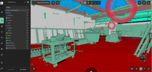
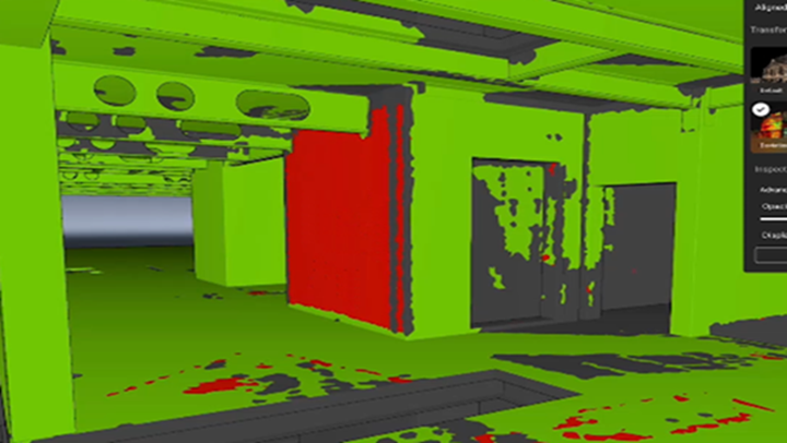
Detect deviations early with Scan vs BIM Capabilities
Catch issues early to avoid costly rework, delays, and budget overruns. Explore the space in 3D, analyze tolerance ranges, and use point-by-point queries to view deviations with precision anywhere on the model.
Feature highlights:
- Prevent rework and delays by identifying out-of-tolerance work early
- Increase accountability by validating installations as they happen
- Provide Proof of Quality & Compliance to Owners with high-precision data
- QA/QC As-Built BIMs against real world data
- Optimize the fit of manually aligned data with Auto-Align, using Cyclone 3DR’s best-fit algorithms right in the browser.
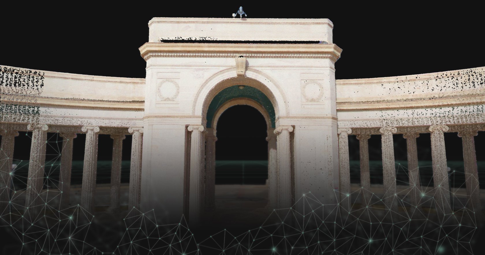
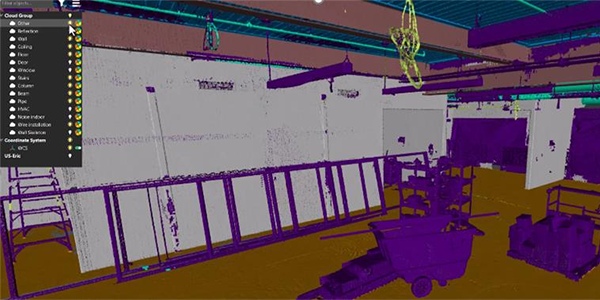
AI-Powered Classification for Smarter Data Organization
AI powered classification improves deliverable creation accuracy by removing unwanted elements such as construction materials or debris, resulting in cleaner point clouds for model creation. Keep teams working locally with available IT hardware resources by running time-intensive classification in HxDR Reality Cloud Studio and view the results when freely streaming to Cyclone 3DR and CloudWorx for your Analysis and BIM workflows.
New capabilities include:
- Efficient Data Filtering: Use AI classification to automatically identify, color-code, and hide non-essential elements in Scan to BIM and Scan vs BIM workflows, helping teams focus on key components for modeling and analysis.
- Streamlined Workflow: Run AI classifications in the cloud and stream directly to CloudWorx or Cyclone 3DR with no manual file handling
- Optimized Visualization: Get clearer, more accurate Scan vs BIM views for faster, better-informed decisions
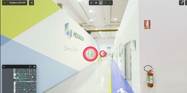
Immersive Smart Visualization with Upgraded Navigation Experience
Experience a more immersive and natural way to navigate your data with an all-new navigation experience, offering smooth motion perception and optimized performance during movement. Plus, new gamer-style hotkeys for users familiar with 3D gaming environments.
Expanded capabilities include:
- Customizable Starting Point: Define the initial viewpoint within the panoramic scene to reduce visual clutter, providing a cleaner and more focused introduction to the project
- Immersive Navigation: Experience movement within the panoramic frame, allowing users to virtually “walk through” spaces for an immersive experience
- Optimized Performance: Enjoy faster loading times and smoother transitions between viewpoints
- Cost-Effective Hardware Performance: Access and interact with light-weight panoramic views without the need for high-end IT hardware
- Advanced Measurement Tools: Utilize point cloud magnifiers within specific areas of the panorama to perform precise measurements directly within the visual context
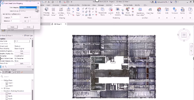
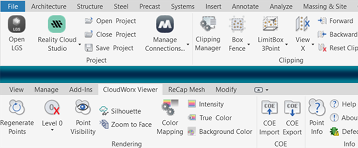
CloudWorx Viewer for Revit – Stream Your Point Clouds Instantly
Enhance collaboration and project coordination across your AEC workflows with the new, free CloudWorx Viewer for Revit, now featuring direct streaming from HxDR Reality Cloud Studio. Built for today’s distributed teams, this integration removes the need for large local files and simplifies access to up-to-date site data. With the free plugin, stakeholders and project teams can stream scan data directly into Revit at no added cost, enabling fast, efficient interaction with project visuals and real-time site intelligence.
New capabilities include:
- Efficient Data Filtering: Use AI classification to automatically identify, color-code, and hide non-essential elements in Scan to BIM and Scan vs BIM workflows, helping teams focus on key components for modeling and analysis
- Streamlined Workflow: Run AI classifications in the cloud and stream directly to CloudWorx or Cyclone 3DR with no manual file handling
- Optimized Visualization: Get clearer, more accurate Scan vs BIM views for faster, better-informed decisions
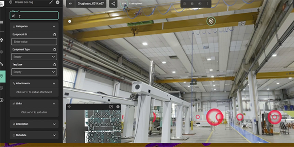
Enhanced GeoTags Built for Real Project Needs
New GeoTag enhancements allow you to add custom fields with free text and/or predefined dropdown lists, tailored to each project’s needs. You are no longer limited to a uniform setup across your organization as each project can have its own unique configuration of unlimited metadata categories per GeoTag
Key improvements include:
- Enhanced GeoTagging Capabilities: Capture GeoTags in the field and maintain them through project delivery, ensuring consistent location-based data tracking
- Accessibility Across Stakeholders: Use GeoTags as collaborative tools to annotate assets, assign tasks, and share insights across teams
- Categorize GeoTags: Create unlimited custom categories for filtering and organizing GeoTags
- Efficient Asset Identification: Identify specific objects or areas within the asset for focused analysis, improving maintenance planning and execution
HxDR Documents
Access workflows and stay updated with release notes for HxDR Reality Cloud Studio.